GCNKAA logo

GCNKAA

ApartmentHeadlines.com
Facebook-f Twitter Instagram Linkedin Envelope Youtube
You are at:Home»COVID»COVID-19 Integrated County View Interactive Map

COVID-19 Integrated County View Interactive Map

0
By Rebecca McLean on September 9, 2021 COVID

The CDC has a powerful 
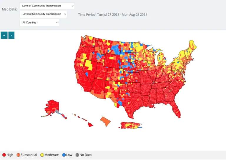
interactive COVID-19 map that provides an integrated county-level view of Covid-19 infections.  The CDC says it allows for the exploration of standardized data across the country and it allows for the exploration of standardized data across the country.


https://covid.cdc.gov/covid-data-tracker/#county-view

Share. Facebook Twitter Pinterest LinkedIn Tumblr Email
Rebecca McLean

Related Posts

Studies Used for Eviction Moratorium Flawed

Landlord Requires Tenants to Be Vaccinated – Is it Legal?

Rental Assistance Funds Slow to Reach Those In Need

Leave A Reply

You must be logged in to post a comment.

Survey

Latest Apartment Advantage

Facebook-f Twitter Instagram Linkedin Envelope Youtube
GCNKAA logo

Copyright © Greater Cincinnati Northern Kentucky Apartment Association
All Rights Reserved.

7265 Kenwood Road, Suite 100 | Cincinnati, OH 45236
Phone: (513) 407-8162 | info@gcnkaa.org

​Get Our Exclusive Members APP

Type above and press Enter to search. Press Esc to cancel.